RIKEN
-If we could cover all of Kyushu with the latest weather radar-
Collaboration with Takemasa Miyoshi, Team Leader of the Data Assimilation Research Team, RIKEN Center for Computational Science (Senior Researcher, Miyoshi Prediction Science Laboratory, Pioneering Research Division, Deputy Program Director, Mathematics Creation Program), Yasumitsu Maeshima, Research Fellow, and others The research team used the state-of-the-art phased array weather radar[2] to predict the linear rainfall belt[1] that brought the heavy rain in July 2020. We evaluated the usefulness of the system when it was virtually deployed across Kyushu, and showed that it could greatly improve the accuracy of predicting the occurrence of torrential rain due to linear rainfall belts.
The results of this research are expected to improve the prediction accuracy of linear precipitation belts, which are becoming more threatened by global warming, and to propose new prediction techniques and observation systems for mitigating damage.
In order to prepare for heavy rains caused by linear rainfall belts that generate cumulonimbus clouds one after another over a wide area, we will improve weather forecasting by simulation by strengthening observations and developing forecasting technology that makes advanced use of the obtained data. is important. For this reason, the research method that simulates a virtual observation system and evaluates its effectiveness for numerical weather forecasting is called Observation System Simulation Experiment (OSSE)[3].
This time, the joint research team performed OSSE using the supercomputer "Fugaku"[4]. Specifically, we quantified the atmospheric conditions around the linear precipitation belt that caused the torrential rain in July 2020, and simulated observation data from a virtual deployment of state-of-the-art phased array weather radars throughout Kyushu. . As a result, it was quantitatively confirmed that by capturing the three-dimensional structure of rain clouds without any gaps using the phased array weather radar, the prediction accuracy of heavy rainfall in linear rainfall zones can be greatly improved.
This research was published in the scientific journal "SOLA" (March 7).
As global warming progresses, heavy rainfall disasters due to linear precipitation belts occur almost every year, especially in summer, and the threat is increasing. In order to prepare for torrential rains that have never been experienced in the past, it is effective to improve weather forecasting by simulation (numerical weather forecasting) by enhancing observation and developing forecasting technology that makes advanced use of the obtained data. .
In 2016, team leader Takemasa Miyoshi and his team produced a ``weather forecast up to 30 minutes with a resolution of 100 m, updated every 30 seconds,'' which was a guerrilla rainstorm that was incomparable in terms of space and time[5]. using the K supercomputer [6]Note 1). Based on this method, in 2020, we will use the state-of-the-art Multi-Parameter Phased Array Weather Radar (MP-PAWR) [7] installed in Saitama City, Saitama Prefecture to observe rain clouds every 30 seconds. Using detailed observation data and the supercomputer Oakforest-PACS[8], we conducted a real-time demonstration experiment of super-fast precipitation forecasts for the next 30 minutes, updated every 30 seconds, in the Tokyo metropolitan area. Note 2). Furthermore, in 2021, using the supercomputer "Fugaku," we conducted a real-time demonstration experiment with 1,000 ensemble calculations, which increased the calculation scale by 20 timesNote 3).
This time, we worked to improve the prediction of linear rain zones by utilizing the "big data assimilation" technology that makes use of the observation big data of the phased array weather radar that we have cultivated independently. A single Phased Array Weather Radar can observe rain clouds 60km away, so it is sufficient to detect guerrilla rainstorms caused by rapid development of a single cumulonimbus cloud. However, linear precipitation belts are formed by the organization of many cumulonimbus clouds over a range of several tens of kilometers to hundreds of kilometers. A single phased array weather radar cannot capture the whole picture, but if we can deploy multiple radars over a wide area and combine the data obtained, we can capture rain clouds over a wide area such as a linear rain belt. will be
If it is possible to evaluate in advance what kinds of observation and prediction techniques are effective, it will be useful for designing effective observation and prediction systems. In particular, it takes a long preparation period and a large amount of money to deploy new observation equipment and develop prediction technology that utilizes this equipment. A research method that simulates such a virtual observation system and evaluates its effectiveness for numerical weather forecasting is called "Observation System Simulation Experiment (OSSE)." In 2021, team leader Takemasa Miyoshi and others will use this OSSE method to evaluate the effectiveness of a new observation system equipped with weather radar on geostationary meteorological satellites and improve forecasts of strong winds caused by typhoons. Note 4).
In this study, we used Fugaku to simulate the observation data of the linear rainfall belt that caused the heavy rain in July 2020 by deploying a phased array weather radar over the entire Kyushu area. OSSE was conducted to evaluate whether this huge amount of observational big data is effective for numerical weather forecasting.

The joint research team first conducted virtual observations when deploying phased array weather radars at a total of 17 locations at local meteorological observatories and special regional meteorological observatories in Kyushu. We simulated the data (Fig. 1). The target was the linear precipitation belt that brought record heavy rain around the Kuma River in southern Kumamoto Prefecture from around 6:00 pm on July 3, 2020 to the 4th of the following day (Japan time). Using the 1km-square regional weather model SCALE[9], a 600km-square area centered on Kyushu was simulated using the supercomputer "Fugaku". This simulation result was used as the correct data (Nature run) in this research. From this correct data, observation data of radar reflection intensity[10] and radial wind[11] by the phased array weather radar were calculated.
Fig.1 Virtual Phased Array Weather Radar Network
The red dots are the 17 points where the phased array weather radar was installed, and the orange shades are the observation range of the radar.
Next, we tried another simulation experiment (NO-DA) that did not reproduce the linear precipitation belts well. Then, using the Local Ensemble Transform Kalman Filter (LETKF)[12], we conducted two numerical weather forecast simulation experiments assuming observation data from all 17 phased array weather radars. rice field.
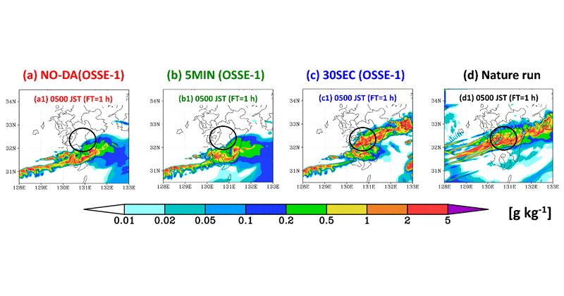
One is an experiment (30SEC) using phased array weather radar data every 30 seconds, and the other is an experiment (5MIN )is. As a result, the correct data (Nature run) shows heavy rainfall in a linear rainfall belt extending several 100km from east to west centering on the southern part of Kumamoto Prefecture (Fig. 2d), while the NO-DA experiment deviates more than 100km to the south. The heavy rain around the Kuma River was not reproduced (Fig. 2a). The 5MIN experiment with 5-minute radar data also did not improve the prediction similarly to the NO-DA experiment (Fig. 2b), but the 30SEC experiment improved this significantly (Fig. 2c). It was confirmed that the phased array weather radar network deployed throughout Kyushu greatly improves the prediction of linear precipitation belts.
Fig. 2 Horizontal distribution of raindrops one hour ahead, starting at 4:00 a.m. on July 4, 2020 (JST)
As described above, the phased array weather radar data every 30 seconds not only predicted guerrilla downpours occurring in a narrow area in a short time, but also organized multiple cumulonimbus clouds like linear rain belts. It was newly found that it also contributes to the improvement of prediction of large-scale phenomena.
Through this research, by deploying 17 phased array weather radars over a wide area of Kyushu, it is possible to predict the linear precipitation belt that caused the heavy rain in July 2020. was found to be significantly improved. It is expected that this result will lead to the proposal of new prediction technology and observation system to improve the prediction accuracy of linear precipitation belts, which are increasing threats due to global warming, and to reduce the damage.
In addition, in this research, we constructed a frame of OSSE by Local Ensemble Transform Kalman Filter (LETKF) using regional weather model SCALE on the supercomputer "Fugaku". Utilizing the computing power of Fugaku will enable unprecedented large-scale OSSE, and is expected to contribute to the design and study of observation systems and forecasting technology looking 10 or 20 years into the future. . Starting in 2022, the Japan Meteorological Agency will start providing information on the possibility of heavy rainfall due to linear rainfall belts half a day in advance, and by 2030, it will forecast with a high probability of torrential downpours associated with linear rainfall belts. I have a plan Note 5). This research is expected to contribute to the development of such prediction systems.
Takemasa Miyoshi, Team Leader, Data Assimilation Research Team, RIKEN Center for Computational Science Laboratory Chief Researcher, Mathematics Creation Program Deputy Program Director) Postdoctoral Researcher Yasumitsu Maejima
Meteorological Research Institute, Meteorological Agency Hiromu Seko Director Takuya Kawabata
This research was conducted by the Japan Science and Technology Agency (JST) Strategic Basic Research Promotion Program AIP Acceleration Project "Big Data Assimilation and New Developments in Real-Time Weather Forecasting by AI (Principal Investigator: Takemasa Miyoshi)”, CREST Research Project “Establishment and Social Implementation of On-Device Learning Technology (Research Director: Hiroki Matsutani, Lead Collaborator: Takemasa Miyoshi)”, International Science and Technology Joint Research Promotion Project Strategic International Joint research program (SICORP) "Monitoring the resilience of freshwater ecosystems using advanced ICT (Principal Investigator: Michio Kumagai, Lead Collaborator: Takemasa Miyoshi)" Area 2: “Large Ensemble Meteorological and Atmospheric Environment Prediction for a New Era Contributing to Disaster Prevention and Mitigation (Representative: Masaki Sato, Collaborator: Takemasa Miyoshi)”, Foundation for Computational Science (FOCUS) Research and Education Center (COE) Formation promotion project "Disaster science research that contributes to urban planning based on multiple disaster risk assessments (research representative: Hirofumi Tomita, research co-investigator: Takemasa Miyoshi)" "Computational science research that contributes to the formation of a resilient society considering different time scales" (Principal Investigator: Satoshi Oishi, Co-Investigator: Takemasa Miyoshi)”, Japan Aerospace Exploration Agency (JAXA) 2nd Earth Observation Research Announcement “Advancement of Precipitation Prediction Algorithm by GPM Observation Data Assimilation” (Principal Investigator: Tatemasa Miyoshi)", Japan Society for the Promotion of Science (JSPS) Grant-in-Aid for Young Scientists, "Assimilation of ultra-high-frequency and high-resolution lightning emission data for high-precision guerrilla rain forecasts" (Research Director: Yasumitsu Maeshima) ”, RIKEN Pioneering Project “Prediction for Science (Principal Investigator: Takemasa Miyoshi)”, RIKEN Pioneering Project : Tatemasa Miyoshi)", RIKEN Engineering Network open-call project "Development of research methods for accumulating plant phenotypic data using artificial weather equipment that reproduces weather forecast data" (Principal Investigator: Minami Matsui, Co-Investigator : Takemasa Miyoshi)”.
Regarding large-scale computer resources, supported by the Ministry of Education, Culture, Sports, Science and Technology supercomputer "Fugaku" Results Creation Acceleration Program Area ② "Large Ensemble Meteorological and Atmospheric Environment Prediction for a New Era Contributing to Disaster Prevention and Mitigation" (Project Number: hp200128) Done.
Takemasa Miyoshi, Team Leader, Data Assimilation Research Team, RIKEN Center for Computational Science Laboratory Chief Researcher, Mathematics Creation Program Deputy Program Director) Postdoctoral Researcher Yasumitsu Maejima
Takemasa Miyoshi (left), Yasumitsu MaeshimaRIKEN Public Relations Office Press Contact Form
Inquiry form


![A workaround that can be used immediately after the iPhone 13 freezes (Lifehacker [Japan version]) --Yahoo! News](https://website-google-hk.oss-cn-hongkong.aliyuncs.com/drawing/article_results_7/2022/3/3/45e4bce7ecbeb696b3a7fb4669c70965_1.jpeg)